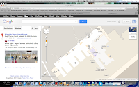
 Adelaide Airport already had Google Maps for indoors, and recently it also introduced Google Street View for indoors to offer a virtual tour. This is the second airport in the world to use Google Maps' indoor
‘Street View’ technology. Users can explore and discover gates and restaurants via this experience. Shops at the airport now have an opportunity to also advertise and offer coupons for users. Users are even able to browse and experience the airport down one of the aerobridges and out
alongside the edge of the runway in a 360 degree experience.
Adelaide Airport already had Google Maps for indoors, and recently it also introduced Google Street View for indoors to offer a virtual tour. This is the second airport in the world to use Google Maps' indoor
‘Street View’ technology. Users can explore and discover gates and restaurants via this experience. Shops at the airport now have an opportunity to also advertise and offer coupons for users. Users are even able to browse and experience the airport down one of the aerobridges and out
alongside the edge of the runway in a 360 degree experience.Google Street View is available through the airport's Google Business Photos initiative. The virtual tour is composed of high quality 2436 HDR (High Dynamic Range) images linked together in 203 panoramic photos to cover the two levels of the terminal, the short-term car park and the pedestrian plaza. A link to the Adelaide Airport in Google Maps can be found here.
